Geocaching: A "Treasured" Experience with GPS
There is nothing like a little friendly competition to pique interest, and so it was on July 3, 2004, at the National Federation of the Blind's (NFB) convention in Atlanta. Pulse Data HumanWare, of California, and VisuAide, of Quebec, Canada, teamed up to sponsor a competitive "treasure hunt" to generate interest in their products. Each company sells a product that is designed to assist people who are blind or have low vision in using the global positioning system (GPS) for wayfinding and locating information. Ten teams of two people each who were blind or had low vision, five using VisuAide's Trekker and five using Pulse Data's BrailleNote, both of which were equipped with GPS software, set out to follow riddles to the desired destinations.
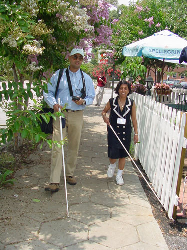
Caption: One treasure hunt team uses the Trekker.
Although these products are reviewed in this issue of AccessWorld, a brief description is in order here. Pulse Data's product consists of a BrailleNote or VoiceNote (personal organizers and notetakers about the size of a hardcover book) and an attached satellite receiver (about the size of a mobile phone). The GPS software from Sendero Group is loaded onto the BrailleNote or VoiceNote, and thus all information is read via that device. A shoulder strap attached to the personal organizer holds the receiver in place. The Trekker is much smaller. Its software is loaded onto a handheld personal digital assistant (PDA). The PDA unit, satellite receiver, and small speaker are mounted on one strap and worn about the neck. This device has speech output only.

Caption: Another team uses the BrailleNote GPS.
Starting the Hunt
GPS receivers typically have difficulty picking up satellite signals in areas that are congested with tall buildings. For that reason, the event was moved out of the downtown area where the NFB convention was located and into a quiet area that was mostly residential with some businesses. All the teams began at a CVS pharmacy. Once given the first riddle, it was up to the participants to determine the names of the streets nearby and the direction of travel that would move them toward their destination.
Both devices contained U.S. maps, thus giving the participants the names of streets and intersections and the direction of travel. The software tells you your location and direction of travel. Say, for instance, that you are headed east on High Street with the next intersection being Main Street. You know from exploring with the GPS device (offline while standing still) that you will need to go north on Main Street to reach your destination. The device announces when you reach Main Street, confirms that you are going north when you turn left, and provides the name of the next intersection as you approach.
For reasons that remained unclear, the organizers from VisuAide and Pulse Data HumanWare chose to create points that were make-believe. A clue, for example, might be quickly interpreted to be pointing toward a Starbucks coffee shop. Sure enough, exploring the prerecorded list of way points, a Starbucks was located, leaving the participants with the task of mapping the route to get there. The coffee shop itself, however, did not exist. Instead, a volunteer was stationed there to announce to the teams as they arrived that that particular spot had been designated the Starbucks spot for the purposes of the game.
The weather was extremely warm that day, with temperatures in the 90s and high humidity, so a few participants dropped out early. Most intrepid souls persisted. Five riddles, two miles, and a few hours later, winners Kelly Prescott, of South Lebanon, Ohio, and Robert Smith, of Atlanta, Georgia, reached the final destination and brought the treasure hunt to an end. The winning team was provided with one of each product. (Robert Smith chose the BrailleNote software, and Kelly Prescott chose the Trekker.)
When Wayfinding Is Way Fun
NFB promoted this particular treasure hunt to its members and certainly set a precedent in incorporating such an event into a national convention. The concept of using technology to ferret out a "secret" spot is not a new one, however—to either blind or sighted individuals.
Michael May, CEO of Sendero Group, is renowned for many reasons, one of which is his passionate pursuit of adapting GPS software for use by people who are blind or have low vision. Under the banner of "Way Fun," May and others organized a weekend excursion in California's Gold Country in September 2003 and a 10-day trip to Ireland and Scotland in September 2004. The first Way Fun event drew about 40 participants, both blind and sighted. Each team of 4 or 5 participants was equipped with at least one BrailleNote or VoiceNote loaded with Sendero's GPS software and satellite receiver and a set of instructions for points to discover. Way Fun rules dictate that the only information that teams can use is that provided by the GPS software or through auditory, tactile, or other clues that are gleaned from traditional orientation and mobility techniques. Some exploration is done on foot, and some is done in cars. The sighted driver of each car takes directions from the blind passengers. For the 2003 Way Fun weekend, participants navigated Volcano, Jackson, and Sutter Creek, California, following written clues to, in this case, real points of interest. Richard Rueda, a visually impaired participant, said that he knew about the software before the weekend but did not realize how powerful it actually was. With the software on his VoiceNote, he learned that he could identify a location through latitude and longitude or by typing in an address. "The first day out," he recalled, "we just wandered around Volcano—finding the shops and the pubs. We plugged in the address of the cemetery and learned it was 1½ miles east. By following the information we got from the GPS software, we went up a hill—and we were there! It was mind-blowing that I could actually do that without sighted assistance!"
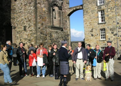
Caption: The Way Fun group tours Edinburgh Castle.
In the Way Fun adventures, there are no prizes (except perhaps discovering a special bottle of wine). The competition is simply in finding the secret destination without sight.
"Caching" On
Sighted people around the world have been participating in "treasure hunts" using technology and GPS since May 2000, when President Clinton removed the restrictions on the availability of information from the satellites. Previously, the greatest accuracy was available only to the military, but the Select Availability Act opened it to civil and commercial uses as well. The sport is called geocaching (pronounced jee-oh-cashing) and has now spread to all 50 states and 211 countries. Clues or instructions are obtained from various Internet sites, and treasure is tracked accordingly. Typically, the thrill is in finding the specified spot, with the prizes, if any, being of no or little value. Families, students, and groups of all ages and configurations are seeing parts of the world they might not otherwise see because the routes followed in geocaching lead to exploration.
And that is exactly what it is about for geocachers who are visually impaired as well. In fact, GPS software arguably gives visually impaired people the first real opportunity to do some casual exploring. Although the ultimate destination on a Way Fun expedition may be, for instance, a pub in Dublin, participants can enjoy other discoveries—a shop, a museum, an unusual flower—along the way; they can even enjoy getting lost. For Mike May, the value of getting lost and the discoveries made in doing so are a large part of what the fun is all about.
Geocaching, in other words, has benefits on multiple levels for people who are visually impaired. First, as the game of geocaching gains more and more attention from people around the world, people who are visually impaired can join the trend as well. Second, in the process of participating in events like the Atlanta Treasure Hunt and Sendero Group's Way Fun trips, a growing number of people who are visually impaired are learning the power of GPS software for exploring environments and navigating independently.
The Thrill of the Hunt
Paul and Kathy Shelton, an Oklahoma couple who are blind, have participated in both the California and Ireland-Scotland Way Fun trips. Paul clearly recalled finding a cave, a grocery, and a picnic spot in Volcano—and the thrill that accompanied each discovery, along with wrong turns and missed entrances. Before the event, he said that he was amazed that the software could distinguish between the highway itself and the exit ramp and could identify his own address accurately, but the experience of using it in the geocaching expedition made the power of the tool even clearer.
Richard Rueda was sufficiently impressed by his experience with the group in Volcano that he bought the software for his own VoiceNote a month later. Today, he uses it routinely to locate the addresses of his new clients as a rehabilitation counselor for the state of California and frequently recommends it to others as an important tool for independence and searching for a job.
And Kelly Prescott, the proud winner of the Atlanta treasure hunt, is using his Trekker in a variety of ways. As a passenger in his wife's car, he said, he has learned a great deal about the names and layout of streets in nearby Cincinnati. In his more rural neighborhood of South Lebanon, Ohio, he said, it is a real treat to go for a walk with his guide dog without having to concentrate on counting blocks. (The GPS products can announce streets as they are crossed.)
Certainly, there are shortcomings to using a GPS product for navigation. Sometimes, the commercial maps offer a name for a road that does not match its sign. The preloaded points of interest may tell you that there is a gas station straight ahead when actually the property now houses an apartment complex. Maybe the weather or the configuration of buildings blocks out the satellite signal when you want it most, or the signal just cannot find a point of interest you know you have recorded recently. As a tool or a toy for people who are visually impaired, however, the benefits of GPS software are greater than the drawbacks and are constantly becoming more so. The products available from VisuAide and Pulse Data Humanware are steadily improving, and other assistive technology companies are introducing GPS products, too. Strong orientation and mobility skills, along with a white cane or guide dog, are enhanced by the addition of GPS devices. But treasure hunts (whether for fictitious points and big prizes or bona fide locations and huge satisfaction) are putting a new face on the business of navigating for people who are visually impaired.
For More Information
For more information about geocaching, visit <www.geocaching.com>. For information on Way Fun expeditions, go to the web site <www.senderogroup.com>.